UNESCAP Conducts Second Machine Learning Training for Vanuatu Land Cover Estimation
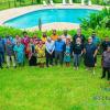
Following the successful April program on "Machine Learning and GIS for Land Cover Estimation," the Vanuatu Bureau of Statistics (VBoS) recently collaborated again with the United Nations Economic and Social Commission for Asia and the Pacific (UNESCAP) to conduct a five-day follow-up workshop held from July 8th to 12th, 2024. This intensive training further equipped VBoS staff and representatives from relevant Vanuatu government ministries with advanced skills in leveraging Machine Learning (ML) and Geographic Information Systems (GIS) for land cover estimation.
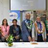
The workshop was led by a team of UNESCAP experts:
- Mr. Richard Tonkin, Statistician, UNESCAP
- Ms. Blanca Perez Lapena, Geospatial Expert Consultant, UNESCAP
- Mr. Christophe Bontemps, Statistician/Lecturer, SIAP, UNESCAP (Remote)
The July workshop shifted the focus towards practical application and building long-term capacity for land account compilation, a cornerstone of disaster preparedness and resource management in Vanuatu.
- Hands-on QGIS Training: Participants received in-depth training using QGIS, a powerful open-source GIS platform, to gain practical experience in land account production.
- Strengthening Collaboration: The workshop fostered stronger collaboration between land cover map producers and VBoS technical experts, establishing a more efficient workflow for future projects.
- Roadmap Development: Participants actively collaborated with UNESCAP to develop a comprehensive roadmap outlining the next steps for independent land account production in Vanuatu.
- Comprehensive Land Account Workflow: The training established a standardized workflow for land account compilation, including satellite imagery acquisition, reference data creation, model development, land cover data adjustments, and interpretation of land accounts.
- Roadmap for Future Activities: The collaborative roadmap empowers Vanuatu to independently produce land accounts, enabling data-driven decision-making for disaster risk reduction and sustainable development.
This enhanced expertise will be instrumental in generating land accounts that provide valuable data for managing Vanuatu's natural resources, environment, and agriculture – all critical aspects of building long-term resilience against natural disasters.